FLOOD WATCH – Lake Nipissing Shoreline in North Bay and Callander
Flood Outlook – elsewhere in NBMCA watershed
Message Number: 2024-08
Issued: April 18, 2024, at 10:30 PM EDT
From: NBMCA Duty Officer, Angela Mills
FLOOD WATCH notifies that the potential for flooding exists within specific watercourses and municipalities. Municipalities, emergency services and individual landowners in flood-prone areas should prepare.
Watershed Conditions Statement – Flood Outlook gives early notice of the potential for flooding based on weather forecasts calling for heavy rain, snow melt, high wind or other conditions that could lead to high runoff, cause ice jams, lakeshore flooding or erosion.
If you have a flood emergency, please contact your municipality. If you live in an unincorporated township, please contact the Ministry of Natural Resources and Forestry (MNRF) – North Bay District.
A FLOOD WATCH continues for the Lake Nipissing Shoreline in the City of North Bay and Municipality of Callander.
A FLOOD WATCH has ended for Mattawa River downstream of Hurdman Dam to the confluence with the Ottawa River in the Town of Mattawa.
A Watershed Conditions Statement – Flood Outlook remains in effect for the remainder of the North Bay-Mattawa watershed, including Mattawa River downstream of Hurdman Dam.
This is an update to the previous Message Number 2024-07 dated April 15, 2024.
Current Conditions:
Water levels and flows responded significantly to last week’s rain. Total rainfall recorded at the North Bay Airport for April 11-13 was 69 mm. This is almost equal to the normal monthly total precipitation expected for April (72 mm).
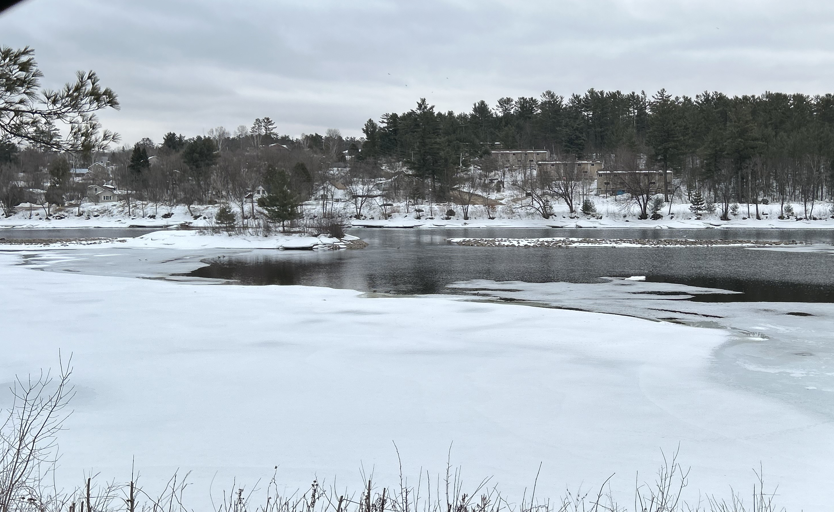
The water level on Lake Nipissing is high. East winds have shifted the Seiche (the wind-driven water level) toward the west side of the lake. This has caused local water levels to fluctuate by as much as 19 cm over the past 24 hours. The water level on Lake Nipissing is regulated by dams operated by the federal government.
The water level on the Ottawa River at Mattawa has decreased by about 44 cm from its peak on April 14. The water level on the Ottawa River at Mattawa is forecast to remain high but stable, per the Ottawa River Regulation Committee. Water levels on the Ottawa River are managed by upstream dams and reservoirs operated by provincial and federal governments through the Ottawa River Regulation Committee.
Water levels in the remainder of the watershed have also been decreasing with most areas now near normal for this time of year. Water levels on Trout Lake, Turtle Lake, and Lake Talon are regulated by dams that are operated by the Ministry of Natural Resources and Forestry.
Current water levels can be viewed by searching Station Names “Ottawa River”, “Mattawa River”, “Chippewa Creek”, “La Vase River”, “Wasi River”, and “Lake Nipissing” at https://wateroffice.ec.gc.ca/search/real_time_e.html
Forecasted Conditions:
The ongoing precipitation event was forecast to bring up to 20 mm of rain, cumulative between Wednesday (April 17) and Sunday. Easterly winds are forecast to become southwesterly later today. Winds could gust to 50+ km/h.
The water level of Lake Nipissing is expected to continue to rise and is likely to reach the beginning of flood damage levels in North Bay in the next two to four days, per Public Services and Procurement Canada. For water level and flow information, see https://www.tpsgc-pwgsc.gc.ca/ontario/eaux-water/renseignement-information-eng.html. The changes to water levels on Lake Nipissing depend on the amount of water flowing in from rivers, precipitation, and the amount of water flowing out through the control dams to the downstream French River.
The water level of the Ottawa River at Mattawa is expected to remain stable, per the Ottawa River Regulating Committee. The Ottawa River water levels are managed by dams and reservoirs operated by provincial and federal governments. The Ottawa River Regulation Planning Board posts current data and forecasts on their website https://ottawariver.ca/
Landscape conditions with dormant vegetation and saturated soils have limited capacity to store additional moisture. Local rivers may respond rapidly to additional precipitation.
Historic Flood Conditions:
For comparison, in response to 34.5 mm of steady rain over 12 hours with frozen or saturated soil conditions and minimal remaining snowpack in March 2024, the water level on Chippewa Creek increased by 83 cm over 15 hours, peaking about 3 hours after rain ended.
Additionally, when lake-based flooding occurred on Lake Nipissing in May 2019, the water level on Lake Nipissing at North Bay reached a maximum level that is about 46 cm higher than the present level. The water level was higher than current levels for the period between April 30 and June 27, 2019.
Risk:
A Flood Watch remains in effect for the Lake Nipissing Shoreline in the City of North Bay and Municipality of Callander. Average water level on Lake Nipissing continues to rise in response to inflows from last week’s rain event. Easterly winds have pushed the water in Lake Nipissing to the western side of the lake, causing an apparent water level to fluctuate by as much as 19 cm over the past 24 hours. As the winds change direction becoming southwesterly or westerly, the water in Lake Nipissing will be pushed back towards the East. Local water levels could fluctuate rapidly. The North Bay shoreline will experience higher water levels and increased wave action, heightening the risk for shoreline erosion.
Water levels in the downstream reaches of Lake Nipissing tributaries (such as Chippewa Creek, Parks Creek, Jessup’s Creek, and La Vase River) will be impacted by high water levels on Lake Nipissing. The changes to water levels on Lake Nipissing depend on the amount of water flowing in from rivers, precipitation, and the amount of water flowing out through the control dams to the downstream French River.
A Watershed Conditions Statement – Flood Outlook remains in effect for the other areas of the North Bay-Mattawa watershed, including the Mattawa River downstream of Hurdman Dam. Water levels have responded to last week’s significant rainfall event. Water levels and flows are receding but remain high in many areas. Strong winds and wave action are a concern while lake levels are high. Flooding may occur in low-lying and poorly drained areas. Landscape conditions with dormant vegetation and saturated soils have limited capacity to store additional moisture. Local rivers may respond rapidly to additional precipitation.
All residents, especially those in low lying areas, are encouraged to monitor the conditions that are developing. Banks adjacent to rivers and creeks are very slippery at this time and when combined with fast moving and cold open water, pose a serious hazard. The public is encouraged to keep children and pets away from watercourses and waterbodies.
Municipalities are encouraged to monitor water crossings for debris that may affect the movement of water through culverts and bridges. A close watch on local conditions and updated forecasts and warnings from Environment Canada is also recommended.
Staff at the North Bay-Mattawa Conservation Authority will continue to monitor weather and watershed conditions and update this message based on the changing weather and streamflow conditions.
This message will be in effect until (or updated before) Monday, April 22, at 4:00 PM EDT.
The general public is advised of these messages through the www.nbmca.ca website with the flood status icon and a link to information about current conditions. NBMCA also circulates these messages to local media and social media, posting on Twitter (@theNBMCA), Instagram (nbmcainfo), and Facebook (NBMCA).
The public is invited to share photos of watershed conditions on social media using #NBMCAFlood.
https://www.nbmca.ca/watershed-management/flood-forecasting/flood-watch-status-terminology/
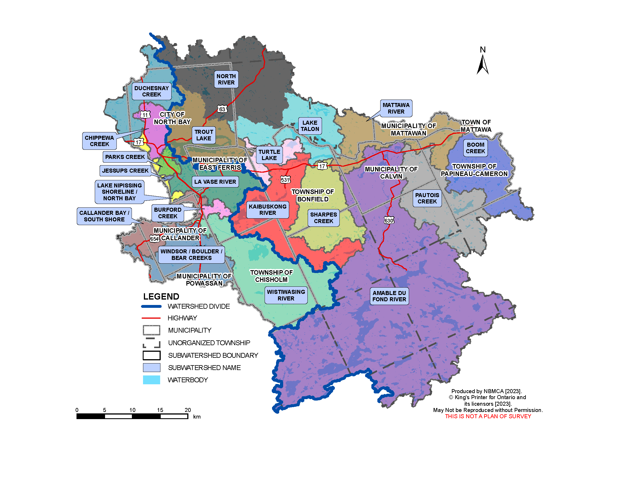
Lake Nipissing
Flows through the dams are based on daily analysis of the current status of the lake and river and as agreed to by the Sturgeon-Nipissing-French-Wanapitei Water Management Group. Weather forecast is considered, along with the inflows from the upper watersheds and outflows through the dam to the French River.
You can view the current level on Lake Nipissing at North Bay on the graph below and the French River at the Water Survey of Canada (WSC) website. Fluctuations in the levels are a result of the strong winds affecting the movement of surface water. Water level and flow information for the South River and Sturgeon River systems is available from Ontario Power Generation (OPG).
Flood warnings for Ontario can be found on the Ontario Flood Forecasting and Warning website.
Why the fluctuation in water level readings on Lake Nipissing? Lake Nipissing can sometimes act like a bathtub, with water shifting in the lake, depending upon wind direction, speed and atmospheric pressure - known as a wind surge or seiche. At times the wind can have such an impact that it may result in the level being higher or lower at the French River gauge compared to the gauge located on the North Bay shoreline.
Mattawa River
The current Ottawa River water level may be viewed at the Water Survey of Canada (WSC) website (note that there is a delay of several hours, and 100m should be added to the gauge reading for metres above sea level).
The Ottawa River Regulation Committee and Ontario Power Generation which operates the Otto Holden Dam provide information online regarding the management of water levels on the Ottawa River. To view water levels and current conditions on the Ottawa River visit the Ottawa River Regulation Planning Board and Ontario Power Generation.
Watercourses and Monitoring throughout the Watershed
There are other watercourses within the NBMCA jurisdiction which are monitored by NBMCA and other agencies. These gauges are maintained by Water Survey Canada - Environment Canada and can be viewed in real-time online.
- Chippewa Creek at North Bay
- Lake Nipissing at French River
- Lake Nipissing at North Bay
- La Vase River at North Bay
- Ottawa River at Mattawa
- Wasi River near Astorville
In addition to the Water Survey of Canada gauges, there are other staff gauges which are monitored by NBMCA or the Ministry of Natural Resources and Forestry:
- Chippewa Creek
- Lake Nosbonsing Dam
- Mattawa River at Hurdman Dam
- Parks Creek
- Trout Lake
- Turtle Lake
- Talon Lake
Is your property at risk of flooding?
If you think that your property may be at risk of flooding, please contact your municipality.
If you live in an unorganized township, contact Ministry of Natural Resources and Forestry District office at 705-475-5501.
More Information
- The North Bay-Mattawa Conservation Authority delivers its flood forecasting program and updates for municipalities, agencies, our partners, and the public as part of our natural hazard management initiatives. These updates are based on the analysis of data and information collected in concert with the following:
- Environment Canada (Weather)
- Mattawa River below Bouillon Lake
- Ministry of Natural Resources and Forestry
- North Bay-Mattawa Conservation Authority
- Ottawa River Regulating Committee
- Ottawa River Regulation Planning Board
- Public Services and Procurement Canada
- Sturgeon-Nipissing-French-Wanapitei Water Management Group
- Surface Water Monitoring Centre
- Water Survey of Canada
- Weather Network